October 2022 in Ireland will be the 17th consecutive month that was warmer than normal – a now established trend driven relentlessly by climate change.
Temperatures were 1.2-2.2 degrees above the monthly mean at 25 of Met Éireann’s main weather stations – and significantly above what is “usual” for this time of year, according to its head of climate services division Keith Lambkin. At four stations it was the warmest October since 1995.
The reality is that such conditions have become normal in a warming world, he says.
This has been mirrored across most of Europe but unseasonably warm weather there is at a more extreme level with temperatures hitting 35 degrees in parts of Spain and France – with exceptionally high temperatures stretching from Scandinavia to North Africa.
READ MORE
Ireland’s weather on the periphery of Europe is often different from the European mainland because of its proximity to the Atlantic but there is always a complex interplay.
Large blocking high pressure systems in central Europe and Greenland have meant low pressure off the southwest of Ireland bring mild air but intense low pressure systems marked by heavy rain and storminess. This static pattern has been in place for weeks and doesn’t look likely to shift anytime soon.
The jet stream is taking a more southerly track than usual across the North Atlantic and then taking a sharp turn northwards as it approaches Europe, maintaining low pressure to the west and northwest of Ireland and the UK and continuing to pull warm and moist air masses up from the south and southwest.
The Irish Sea has experienced much of that storminess – in contrast to traditional path of weather systems hitting the southwest coast.
[ Temperatures in Europe have increased more than twice global averageOpens in new window ]
Is this related to climate change? Lambkin replies starkly: “All weather we get now is related to climate change; even the benign stuff.”
The trends are typical in a warmer world, he adds, where climate disruption is changing the odds.
The recent meteorological data will be fed into supercomputers and increasingly reliable attribution science will confirm the extent to which climate change has impacted on autumn weather across Europe.
There should be no surprise; climate science has flagged what is more or less likely, Lambkin adds. Extreme events become more frequent and intense, even in Ireland.
Significant reductions are expected in average levels of annual spring and summer rainfall in coming years, according to the EPA. Projections indicate a substantial increase in frequency of heavy precipitation events in winter and autumn (by about 20 per cent).
The number of warm days is expected to increase and heatwaves are expected to occur more frequently – each successive decade has been warmer than any preceding decade since 1850. The number of very intense storms is projected to increase over the North Atlantic region, while their winter track may extend further south and over Ireland more often.
There is one positive in all of this; climate projections suggest much of Ireland will have an extended growing season. But recent weather patterns indicate that doesn’t always mean a boost to agricultural production.
Met Éireann confirms it has been much wetter than average in Ireland over the past seven days, with some areas up to 2.5 times as wet as they normally would be at this time of year – with similar conditions predicted for coming days.

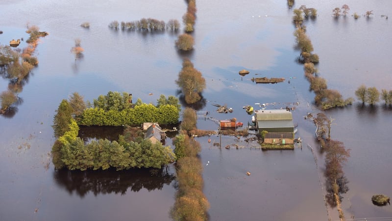
Soils have become saturated particularly in the Shannon river basin and throughout much of the midlands. This has brought an early end to the grazing season for many farmers, which means cattle have to be housed for the short-term, if not longer.
IFA Connacht regional chair Pat Murphy fears it could lead to severe and sustained flooding along the Shannon this winter.
Farmers want the OPW to embark on a preventive approach this winter when managing the Shannon’s water levels, while ensuring that it doesn’t cause problems further downstream.
He highlights the need to avoid the disastrous flooding of 2009 which saw hundreds of farms and farmyards along the Shannon flooded, resulting in livestock being left without winter housing and serious financial implications for affected farmers.
Being so wet so early in the autumn-winter period is causing anxiety in the farming community. “There has been a clear increase in rainfall over the past number of weeks and farmers are contacting me worried about the rising water levels and increased risk of flooding,” Murphy adds.
Meanwhile Europe’s concern relates to heat primarily. It has been the warmest October in Spain for over a century. “One, two days above 30 degrees is normal” for Spain at this time of year, noted Ruben del Campo of Spain’s meteorological service Aemet. “But so many days, no. These are summer temperatures.”

Last Friday, the northern resort of San Sebastián saw the temperature hit 30.3 degrees at 8.30am – well above the seasonal average.
The UK Met Office noted on October 26th in London it was 20.5 degrees, “closer to what we would normally see at the end of August rather than the end of October”.
“We have never observed warmth like this in Europe so late in the year,” tweeted the meteorologist Scott Duncan – who regularly charts extreme weather events online.
This has come on top of a turbulent year of record-shattering events: repeated heatwaves including temperatures in excess of 40 degrees; wildfires and severe flooding episodes all made worse by climate change due to a deadly combination of rising carbon emissions and burning of fossil fuels.
It looks likely that the current pattern will eventually shift into something colder and drier, but it remains to be seen whether this shift ends up being delayed further by the current dominant scenario, according to long-range forecasts by the Met Office and Europe’s ECMWF’s 42-day long-range forecast model.


