Violent storm-force winds, flooding and high tides are expected when Storm Lorenzo makes landfall on Thursday evening.
The storm, originating from the most northern and easterly hurricane on record, was "rapidly approaching" western Europe and "in particular Ireland", Met Éireann said last night. The likelihood of landfall was "high probability", it said.
A combination of high tide, very low atmospheric pressure and high winds gusting at up to 130km/h are likely to lead to flooding, particularly around the Shannon estuary area. Further flooding in parts of the midwest and midlands is possible.

Storm force 11 winds will be accompanied by torrential rain, especially in western counties, with 50mm expected to fall in less than 18 hours and amounts of up 100mm in the mountainous areas of Galway and Mayo.

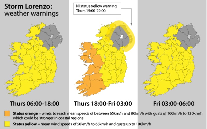
An orange weather alert is in place for counties Cork, Kerry, Limerick, Clare, Galway and Mayo from 6pm on Thursday to 3am on Friday. A yellow weather alert is in place elsewhere from 9am on Thursday to 6am on Friday with gusts of 100km/h expected in most places.
Crisis management teams
Local authorities have activated their crisis management teams and local co-ordination groups. Drains and gullies have been cleared by the teams and sandbags have been prepared.
The Irish Coast Guard has appealed to the public to stay away from coastal areas during this period.
“Stay back, stay high and stay dry,” it said.
Schools in Galway, Mayo, Clare, Cork, Kerry and Limerick are being advised to “err on the side of caution” and close on Friday if they feel there is a risk to students from the impact of the storm.
The National Emergency Co-ordination Group issued a statement on Wednesday warning of the risk posed by trees in high-wind events.
“The most widespread and potentially dangerous consequence of high wind is the risk of trees breaking/falling, possibly bringing down live power lines, posing a danger to motorists and pedestrians in the vicinity,” it said.
Fallen trees
Met Éireann head of forecasting Evelyn Cusack warned of the risk of fallen trees due to a combination of full foliage and saturated soil, which has weakened roots.
Minister for Agriculture Michael Creed urged farmers to wait until the storm had abated before checking on animals.
“Priority is obviously the safety of people and I would reiterate the advice that care should be taken,” he said.


